

Despite a 10% increase in roads and streets in flood-prone coastal areas of Puerto Rico over approximately a decade, neither the Department of Transportation and Public Works (DTOP, in Spanish) nor the Highway and Transportation Authority (ACT, in Spanish) have relocation or elevation projects for state road infrastructure under their charge for long-term adaptation and mitigation, according to an investigation by the Centro de Periodismo Investigativo (CPI).
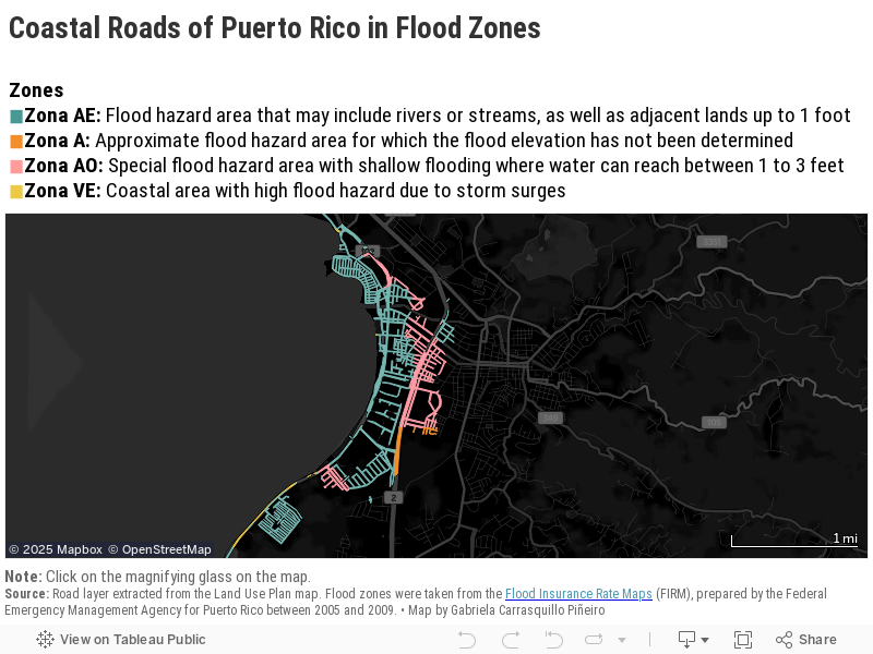
The situation is even more alarming because 101 segments of state roads are located not only in flood-prone areas but also in zones susceptible to coastal erosion, according to a study by the Coastal Research and Planning Institute, affiliated with the University of Puerto Rico’s Río Piedras Campus. Of these segments, 46 are vulnerable to coastal flooding caused by storm surges.
The data analysis was based on the Flood Insurance Rate Maps (FIRM), prepared and approved by the Federal Emergency Management Agency (FEMA). FIRM maps are the official documents adopted by the Planning Board to designate flood hazard areas. After hurricanes Irma and María in 2017, FEMA developed the Advisory Base Flood Elevation Maps (ABFE). These are considered interim maps reflecting the most updated flood zones until FEMA updates FIRM.
The CPI compared road infrastructure in flood zones using both the FIRM and ABFE maps. The analysis revealed an increase from 29% to 39% in road infrastructure situated in coastal flood zones.”
At least 10 of 44 coastal municipalities have begun short-term mitigation projects such as storm drains and placing rocks by the roads under their jurisdiction. Some of these projects would impact state roads managed by the ACT and DTOP. The Department of Natural and Environmental Resources (DRNA, in Spanish) also has two coastal restoration projects in San Juan and Humacao, and a flood control project in Mayagüez, which, according to consulted experts, would mitigate sea level rise, thus protecting nearby roads.
Urgent Need for Long-Term Solutions
María E. Avilés Padilla lives near one of these neighborhoods affected by flooding and coastal erosion. After Hurricane María, she couldn’t go back to her home in the Las Ochenta community in Salinas for five days. The strong waves caused by the cyclone in the Caribbean Sea destroyed the pavement and guardrails of PR-1, which connects to her house. The nearly 700 residents in Las Ochenta were left isolated because the coastal road is their only entry and exit route.
When she finally returned, her property was destroyed, she recalled in an interview with the CPI.
“I’ve lived here for 17 years,” Avilés Padilla said about the area, where the average annual income is $12,500, according to the 2020 Census. This amount is well below the poverty level, which is set at an average of $25,800 for a household of three in Puerto Rico.
“Not long ago, the sea overflowed, and people from there [the lower part of the community] came here, where it’s higher, because the street flooded,” Avilés Padilla recounted about similar occurrences after the impact of hurricanes Fiona in 2022 and Beryl in 2024. “They’ve had to evacuate people from their homes and everything,” she added.
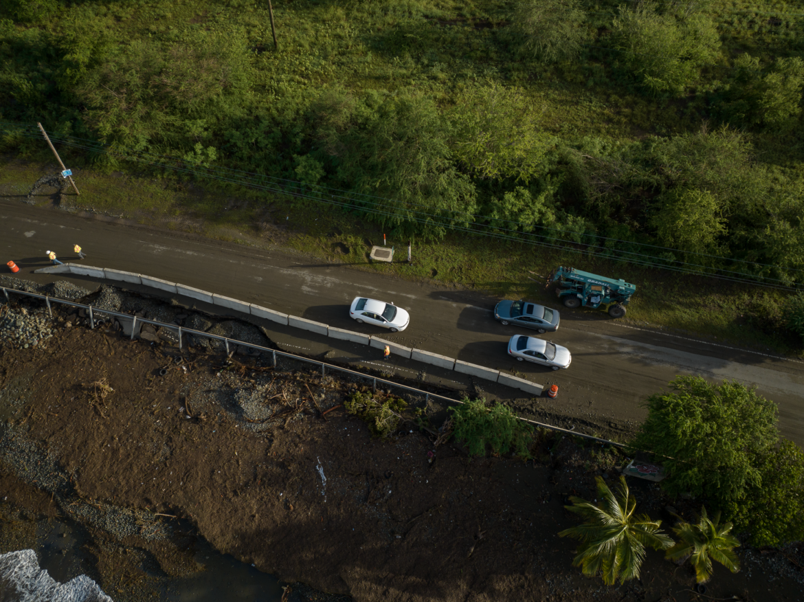
Photo by Abimael Medina | Centro de Periodismo Investigativo
Due to its proximity to the coast, this part of PR-1 is one of the 101 segments of roads at greater risk of coastal flooding, in addition to being in a coastal erosion area, according to the Coastal Research and Planning Institute study. Rising sea levels could exacerbate coastal flooding in the coming decades, making the infrastructure more vulnerable, according to the Climate Change Adaptation, Mitigation, and Resilience Plan. This plan was submitted in 2024 to the Legislature by the Committee of Experts and Advisors on Climate Change (CEACC, in Spanish) but was not addressed, so it should be presented again during this term.
After reviewing the two main planning documents from the DTOP and the ACT, the CPI could not identify any relocation or elevation projects for the 101 coastal state road segments at risk. DTOP Secretary Edwin González Montalvo said the agency is working on replacing bridges at a higher elevation to reduce flood risk but did not specify how many or if any are in the coastal strip.
In an interview with the CPI, González Montalvo acknowledged that the agency lacks long-term adaptation and mitigation projects for roads at risk from sea level rise and coastal flooding. Before being appointed to his current position, the official served as the executive director of the ACT under the previous administration.
“That’s a challenge, that’s the truth,” González Montalvo responded to CPI questions after his confirmation hearing in the Senate. “These are things we address case by case because the funds we receive (…) are already limited for main roads [not municipal].”
Road relocation entails either constructing a detour for the at-risk area or abandoning it entirely to build a new route that is not flood-prone. The scale of the project will depend on the severity of the issue and whether the solution is intended to be permanent or temporary, explained Benjamín Colucci Ríos, a professor in the Department of Civil Engineering and Surveying at the University of Puerto Rico’s Mayagüez Campus and one of the founders of the Transportation Technology Transfer Center.
In a quick search of the 101 state road segments at risk through Google Maps, the CPI found that at least 16 are the only access route for 22 coastal communities.
Maritza Barreto Orta, a former member of the Committee of Experts and Advisors on Climate Change, warned that road relocation and elevation are the only long-term solutions for sea level rise and the eventual increase in coastal flooding. The Climate Change Mitigation, Adaptation, and Resilience Plan projects that by 2050, the sea level could rise by almost two feet.
In the absence of road relocation or elevation projects, Barreto Orta, who directs the Coastal Research and Planning Institute, did not rule out the development of natural barriers or road redesign as short-term solutions. The effectiveness of these measures varies depending on the specific circumstances.
For example, the PR-1 segment leading to Las Ochenta is lined with rocks. Although the rocks were placed there before Hurricane María in 2017, that hasn’t prevented the road from becoming impassable due to flooding during strong surges, according to community residents and regional press reports.
Colucci Ríos warned that coastal flooding and strong waves undermine road pavement. This weakens the asphalt and eventually causes roads to collapse under vehicular overload.
Municipalities Seek Alternatives
The CPI found that the municipalities of Mayagüez, Loíza, Aguada, Ceiba, Aguadilla, Ponce, Dorado, Salinas, Isabela, and Patillas already have federal funds for some projects that can mitigate flooding in their coastal road infrastructure. These funds come from FEMA’s Hazard Mitigation Grant Program and the Community Development Block Grant for Mitigation, managed by the local Department of Housing.
The works would partially protect roads at risk because they would mitigate sea level rise, the CEACC responded to CPI questions.
Barceloneta, Luquillo, Humacao, and Yabucoa submitted proposals to address this issue for the Department of Housing’s mitigation funds but were not selected.
The CEACC told the CPI that installing stormwater management systems, restoring dunes, planting mangroves, and coral reefs would be acceptable adaptation and redesign measures for at-risk road infrastructure. In some cases, the ideal solution would be road relocation and elevation, although these would be costly and complex projects, the Committee acknowledged. The mitigation measure to be implemented will depend on studies of each road. The CEACC added that the least harmful measure for the ecosystem and surrounding communities should be selected.
The Climate Change Plan highlights the urgent need to adapt Puerto Rico’s road infrastructure to the impacts of the climate crisis. The DTOP and ACT are responsible for about 8,000 kilometers of state roads, while another 16,000 kilometers are under municipal jurisdiction as municipal roads.
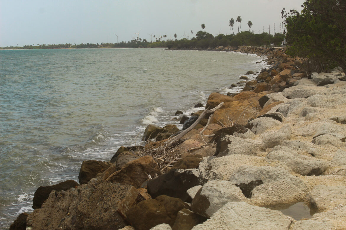
Photo by Luis Joel Méndez González | Centro de Periodismo Investigativo
Colucci Ríos explained that coastal roads in Puerto Rico are severely affected by heavy rains and the vehicular overload they were subjected to after hurricanes Irma and María due to the collapse of roads in the mountainous area. The deteriorating or collapsed bridges in the island’s central regions forced heavy vehicles, such as trucks carrying construction materials, to reroute along coastal roads.
“Due to climate change and sea level rise, the direct impact on the pavement is that the groundwater table rises, weakening the capacity to transmit the [vehicular] load and, therefore, it will fail,” the road engineer explained. The groundwater table is the level of water in the subsurface.
None of the projects approved under the Hazard Mitigation Program for segments exposed to flooding have been built to date. These projects were approved between April 2021 and January 2025.
Projects drag on endlessly
Desde hace tres años, la alcaldesa de Loíza, Julia Nazario Fuentes, espera que FEMA obligue unos $10 millones para dos proyectos que sometió por medio del Programa de Mitigación de Riesgos para la siembra de arrecifes de coral y la restauración de dunas de arena de la playa aledaña a la PR-187. Ambos proyectos, de ser aprobados, protegerían la carretera del litoral del aumento del nivel del mar, así como del incremento en inundaciones costeras.
De acuerdo con la alcaldesa, FEMA le indicó que no ha obligado ninguno de los proyectos por falta de fondos. La obligación de fondos es la asignación del dinero necesario para el desarrollo de proyectos.
“Estamos en una lista [de espera]”, dijo Nazario Fuentes. “En la medida en la que se reciben fondos, ellos van otorgando [fondos] a nuevos proyectos”, explicó.
Mientras espera por FEMA, el Municipio de Loíza ordenó en enero cerrar dos calles que dan acceso a 10 viviendas en la urbanización Parcelas Suárez — cerca de la PR-187 — porque unas fuertes marejadas debilitaron el terreno sobre el cual se encuentran construidas, narró la alcaldesa.
Edwin Cotto, uno de los 45 residentes afectados, dijo que no es la primera vez que las calles en la comunidad colapsan. Por años, los vecinos han reclamado que se desarrolle un proyecto de mitigación a largo plazo para evitar una desgracia.
“Esas olas vienen todos los años para este tiempo [en otoño] y no se ha puesto nada para mitigarlo”, denunció.
For three years, Loíza Mayor Julia Nazario Fuentes has been waiting for FEMA to obligate about $10 million for two projects she submitted through the Hazard Mitigation Program for coral reef planting and sand dune restoration on the beach adjacent to PR-187. If approved, both projects would protect the coastal road from rising sea levels and increased coastal flooding.
According to the mayor, FEMA indicated that none of the projects have been “obligated” due to a lack of funds. The obligation of funds is the allocation of the money necessary for project development.
“We’re on a [waiting] list,” said Nazario Fuentes. “As funds are received, they grant [funds] to new projects,” she explained.
While waiting for FEMA, the Municipality of Loíza ordered in January to close two streets that provide access to 10 homes in the Parcelas Suárez urbanization — near PR-187 — because strong surges weakened the ground on which they are built, the mayor narrated.
Edwin Cotto, one of the 45 affected residents, said it’s not the first time streets in the community have collapsed. For years, neighbors have demanded a long-term mitigation project to prevent a disaster.
“Those waves come every year around this time [in the fall] and nothing has been put in place to mitigate it,” he complained.
The municipalities of Cataño and Vega Baja, which are also waiting for their adaptation and mitigation projects to be approved by FEMA, face similar obstacles.
The Municipality of Cataño submitted a project to the Hazard Mitigation Program for the construction of a rock-lined breakwater and coral reef rehabilitation, which in addition to being a natural barrier against storm surges, would meet the definition of an adequate adaptation measure to protect PR-888 from coastal flooding.
Four years after its submission, FEMA denied the project in late January, confirmed the municipality’s spokesperson, Elliot David Rivera, who added that the municipality will appeal the decision. The project was originally submitted under the mitigation program for Hurricane María, but at the end of 2023, it was transferred to the same program but with funds available for Hurricane Fiona, according to the then-executive assistant to the mayor, Nannette Rodríguez.
The Municipality of Vega Baja also submitted a project to the same FEMA program last October to demolish 13 abandoned properties on PR-686. The municipality made the decision after the DRNA did not give them access to more than $105 million available for these purposes through the Coastal Erosion Emergency Declaration declared by former Governor Pedro Pierluisi. The removal of abandoned structures on the coast is one of the CEACC’s recommendations as a measure to slow down the deterioration of the coastline and maintain control of coastal flooding due to the climate crisis.
The project is in the process of information requirements to ensure compliance with the program, said Carmen Edith Torres, external affairs officer of FEMA’s Joint Recovery Office in Puerto Rico.
For FEMA to approve or deny a project, it must make sure that it complies with its environmental and historical responsibilities according to federal laws and executive orders in force, and that it is effective and viable in terms of scope and cost-effectiveness.
The Municipality of Patillas, on the southern coast, had a flood control project approved two years ago, but it is still not completed due to a lack of labor, said Mayor Maritza Sánchez Neris. The project is still in the design stage and, once completed, will indirectly benefit PR-3, which has suffered coastal flooding and runoff for decades, a problem affecting the Recio sector of the Guardarrayas neighborhood, the Municipal Executive said.
The U.S. Government Accountability Office (GAO) indicated in a report last year that FEMA’s Hazard Mitigation Program has experienced “unexpected delays.”
To reduce bureaucracy in project development, the GAO recommended that FEMA reevaluate information request protocols and the environmental and historical preservation process, and recruit more staff.
The GAO report also acknowledged the problem of labor shortages in Puerto Rico’s overall recovery.
A Dead End
Yabucoa Mayor Rafael Surillo Ruiz told the CPI that he presented a project to the U.S. Army Corps of Engineers (USACE) to install an artificial coral reef along PR-906 to protect it from sea level rise and coastal flooding. However, according to the mayor, the federal agency rejected the proposal because there was no government structure to protect on that route.
For his part, USACE spokesperson Luis A. Deyá clarified that to proceed with an adaptation and mitigation project like the one proposed, “it is not necessarily” required to protect a government structure. Deyá said the mayor has not met with the USACE Caribbean District, which was created in June 2024, but could not confirm if there was a meeting before the District’s establishment.
The Municipality of Yabucoa, on the southeast coast, submitted the same proposal for consideration to the Department of Housing’s Infrastructure Mitigation Program, but the project was not selected due to a lack of funds, said the municipality.
“If no [action] is taken now, in 15 or 20 years (…), the road will have to be elevated, and the government will have to make a multimillion-dollar investment,” Surrillo Ruiz warned.
Since 2018, the Municipality of Barceloneta has repeatedly attempted, without success, to secure funding for dune restoration along PR-681 and 684. These roads are among the most prone to coastal flooding in the northern coast line.
The director of Federal Programs for the Municipality of Barceloneta, Glorimar Villamil Carrión, said the dune enhancement proposal was submitted to the Housing Department’s Infrastructure Mitigation Program in early 2023. She added that months later, the agency informed the municipality that the project was “solid” to obtain federal funds. Then, the municipality set aside another pending project for runoff management and pinned all its hopes on this one.
In the end, the proposal was not selected due to a lack of funds, according to a database that Housing provided to the CPI.
Likewise, the Municipality of Luquillo submitted a coastal erosion control and restoration project. According to Mayor Jesús Gerardo Márquez Rodríguez, this project is of utmost importance because he currently has 12 miles of coast suffering from coastal erosion. The proposal submitted for consideration by the DV aims to maximize available natural barriers to protect life, property, and roads PR-3 and PR-193, the municipal executive indicated.
Like in Barceloneta and Yabucoa, the Luquillo project was not selected due to a lack of funds, according to the Housing project list.
However, the mayor of Luquillo told the CPI that the Housing Department had not informed that the project was rejected and that, on the contrary, the agency told the municipality staff that “the project is pending.”
The Infrastructure Mitigation Program administered by the Housing Department, with around $4.3 billion in CDBG-MIT funds, received 270 applications, of which only 23 were pre-approved, the Housing Department told the Senate. The program has a budget of about $2.4 billion specifically for this type of project.
The director of the Legal Division of the Housing Department Recovery Office, Ruth N. López Alsina, explained to the CPI that the preselected projects accumulated the most points when evaluated for the risks they would mitigate, how numerous the population they would benefit be, and how advanced their designs, permits, and environmental compliance were. Coastal barrier projects received higher scores when evaluated. However, the projects in Luquillo, Barceloneta, and Yabucoa were still not selected.
“These projects (…) received a higher rating or priority under that category compared to the others,” López Alsina indicated. “However, the final score depends on an accumulation of points.”
Innovation in design, implementation plan, and financing with other funding sources were also among the criteria considered, the official added.
Projects not selected due to fund availability could be reconsidered in the future as the program progresses, the official pointed out. However, U.S. President Donald J. Trump adopted as public policy to discontinue programs and grants to address the manifestations of the climate crisis in major federal agencies.
Seeking Other Alternatives
Culebra Mayor Edilberto Romero Llovet is also waiting for FEMA to approve a project that the Marine Environment Society submitted in conjunction with the municipality through the Hazard Mitigation Program to plant mangroves and line the coastline with rocks on PR-252 to mitigate coastal flooding. He wants to replicate the success of a similar project carried out two years ago on PR-250 for about $200,000 in collaboration with the Watershed Protectors organization. That restoration was done with funds from FEMA’s Public Assistance Program.
These projects are an example of collaborations between municipalities and nonprofit organizations to mitigate coastal flooding and sea level rise in the face of the slowness and neglect of government programs for these purposes enabled through federal funds.
Photo provided
The director of the Office of Planning, Environment, Development, and Urbanism of Manatí, Víctor González Narváez, said the municipality has also restored natural barriers with the support of nonprofit and for-profit entities.
He mentioned that they have collaborated with organizations like the Vegabajeños Boosting Sustainable Environmental Development (VIDAS, in Spanish) group and Descendants United for Nature, Adaptation, and Sustainability (DUNAS) to execute the Vega Baja and Manatí Submarine Gardens Natural Reserve Plan, which would protect PR-684 and 686 from coastal flooding. The municipality also collaborated with First Bank for two coastal planting projects through the hiring of specialized personnel and the purchase of part of the vegetation, he said.
The lack of human resources and time to formulate and submit mitigation projects motivated González Narváez to seek support from the nonprofit sector instead of requesting funds from the government.
“It’s a constant struggle with the State, with the agencies,” he said.
So far, Vida Marina (UPR-Aguadilla), Watershed Protectors, First Bank, VIDAS, and DUNAS have worked on at least 25 adaptation and mitigation projects for sea level rise and coastal flooding in more than 15 towns through dune restoration and planting of mangroves and coral reefs near roadways, according to information that the organizations provided to the CPI.
Who Answers for the Communities?
Every time bad weather looms, waves slam the portion of PR-1 that passes through Salinas. Debris and sand block the road, said Ada Ramona Miranda Alvarado, leader of the Las Ochenta community. Residents who are isolated risk not being able to be attended to during medical emergencies.
Two years ago, Miranda Alvarado was practically isolated for three days after Hurricane Fiona. The only way to access the community was in high vehicles.
“Everything the sea dumped was on the road,” she recalled.
However, Salinas press officer Lersy Pastrana said the Municipality of Salinas has no ongoing project to mitigate coastal flooding on that segment of PR-1.
“The municipality does not have its own funds for such projects,” Pastrana said.
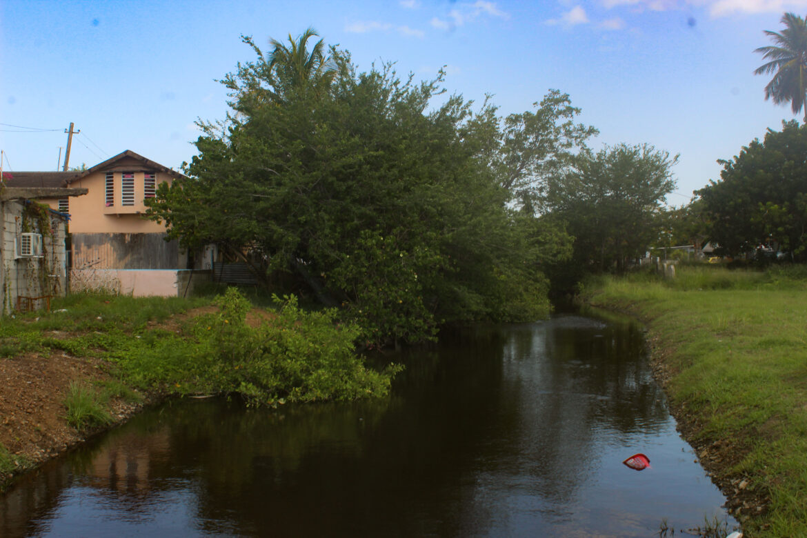
Photo by Luis Joel Méndez González | Centro de Periodismo Investigativo
Former associate member of the Planning Board and professor at the UPR Graduate School of Planning, Norma Peña Rivera, explained that the less accessible a community is, the lower its wealth level will be, as mobility is determined by the presence of roads, on an island that lacks an effective public transportation system.
The DTOP and ACT are responsible for developing road projects in Puerto Rico. However, the Planning Board (JP) is responsible for ensuring that these projects are carried out comprehensively, fairly, and in harmony with the environment, and according to its own organic law, it has the authority to guide Puerto Rico’s comprehensive development. Urban planner Peña Rivera noted that there is no obstacle for the three entities to work together.
However, Marisol Luna Díaz, JP’s information officer, said that the agency is not involved in authorizing or setting parameters for developing road infrastructure projects that respond to the climate crisis.
“These responsibilities fall on the ACT, the DTOP, and the Permits Management Office,” Luna Díaz responded in writing to the CPI. The ACT and DTOP must build according to applicable construction codes and public policies on coastal zone management, as well as elevation in flood zones, stormwater management, and climate change resilience standards, she added.
Luis Joel Méndez González is a member of Report for America.
Methodology
The CPI analysis of the percentage of road surface in coastal and flood-prone areas was done using a Geographic Information System (GIS). The study utilized available data from Puerto Rico’s Road Network in the Land Use Plan (PUT, in Spanish), which includes the surface area occupied by municipal and state streets and roads, as well as information layers from FEMA’s FIRM and ABFE maps, specifically flood zones A, AE, VE, and AO. These are the same zones analyzed in the project “State of Beaches in Puerto Rico After Hurricane María,” led by Dr. Maritza Barreto and funded by FEMA.
For the CPI analysis, roads located within the Coastal Zone were identified. According to DRNA regulations, this zone extends up to one linear kilometer inland from the coastline and as far as necessary to ensure the integrity of the coast’s natural systems. The most up-to-date shoreline data, mapped by the United States Geological Survey (USGS) in 2018, was used for this analysis.
The Coastal Research and Planning Institute of the University of Puerto Rico identified state roads and highways located within the Coastal Zone to assess the 101 road segments in erosion-prone areas and at risk of flooding.
According to FEMA, flooding can result from meteorological and environmental factors, such as rising sea levels or heavy rainfall, as well as from infrastructure changes.
This translation was generated with the assistance of AI and thoroughly reviewed by our editorial team to ensure accuracy and clarity.
Next in Series
3 / 4
¡APOYA AL CENTRO DE PERIODISMO INVESTIGATIVO!
Necesitamos tu apoyo para seguir haciendo y ampliando nuestro trabajo.
