


While the communities near the Río Piedras, in San Juan, and the Culebrinas River, in Aguada, on the western coast, demand the execution of flood control projects that have a minimum ecological and social impact, the US Army Corps of Engineers (USACE) clings to the canalization alternative because it is the least expensive way to address the problem.
The USACE dusted off a project conceived nearly 40 years ago to reduce flooding in several areas of San Juan and proposes to complete it in 2032, after a congressional allocation of $1.5 billion approved the funds for the works that involve altering the natural flow of the river with the construction of a cement wall that redirects its course.
The federal agency says that while the idea may be old, its design was revamped.
“As the project has progressed the design has been continually evaluated and updated with the latest data and design guidance, regulations and criteria, including hydraulic & hydrology, sea level rise, climate change and seismic,” the USACE said in written statements sent to the Center for Investigative Journalism (CPI, in Spanish).
Even if the design conformed to current data, guidelines, and regulations, the USACE project faces another problem: how undesirable this type of construction has become among certain scientists, academics, environmental and community leaders, and even among engineers, when compared to projects based on natural solutions. Nature-based solutions are intended to protect, sustainably build, or restore natural ecosystems. In 2022, US President Joe Biden announced his administration’s strategies to combat climate change based on natural solutions.
“The channeling of rivers is not only contrary to the best practices and planning for flood control internationally, but it is also inconsistent with the road map drawn by President Biden’s administration to face climate change,” said Raúl Santiago Bartolomei, professor at the Graduate School of Planning of the University of Puerto Rico’s Río Piedras Campus.
“The river isn’t just a water channel. The river has meanders [curves]. Straightening a river is the most unnatural action you can do. Once you made a cement channel there, you basically killed the entire ecosystem and everything around it,” said Ana Navarro, a biologist and chemical oceanographer attached to the Sea Grant Program at the UPR in Mayagüez.
The almost general admiration that channeling generated as a work of engineering is questioned today, challenged, and even reversed in countries like Spain, the United Kingdom, and France, where ecological river restoration projects have been carried out, removing dams and infrastructure that alter the natural flow of water.
In the United States, USACE has supported initiatives such as those in Jacksonville, Sacramento, San Francisco, and Denver for nature-based solutions — known as Engineering with Nature — where surfaces were waterproofed and spaces that were green in the past were restored.
Even in Puerto Rico, the Caribbean Ecological Services Office and the Fish and Aquatic Habitats Conservation Program of the U.S. Federal Fish and Wildlife Service (USFWS) work together with other collaborators on projects to eliminate or modify physical barriers in rivers for the benefit of aquatic fauna. In Arecibo, on the North coast, for example, the Cambalache dam located on the Arecibo Río Grande was removed with the aim of restoring the connectivity of approximately 25 kilometers of the river to benefit the ecosystem, aquatic species, and the public, according to what Fish & Wildlife published. The USACE is also active in a canalization project on the Arecibo Río Grande. This construction is one of the 18 projects that this agency has on the agenda for Puerto Rico in the coming years.
The cost in the equation
Among the questions raised by the residents of San Juan and Aguada, on the western coast, are: Why use a channeling model discarded in other places in Europe and several cities in the United States? Why insist on projects in Puerto Rico that affect hydrological ecosystems, disconnect valuable habitats, and cause the displacement of species?
The proposed Rio Piedras project is estimated to cost $3.5 billion. The work will impact 6.2 miles of the canal that crosses San Juan’s urban area and will be split into nine segments that will be built in several phases and separate contracts.
The federal agency said the conditions of the Río Piedras make it difficult to develop alternative models for channeling through levees and channels. As explained in written statements sent to the CPI, the alternative model to the channeling proposed by the community would require the expensive purchase of a huge amount of public, residential, and commercial land. Due to the high levels of urban sprawl in San Juan on the riverbanks, an alternative solution to the channelization would also affect homes and businesses that would have to be relocated along the channel. In addition, major alterations would have to be made to the road infrastructure.
“The economical, environmental, and engineering solution given the conditions is to improve the existing channelized Río Piedras and its tributaries,” the USACE stressed.
The project as designed also requires the acquisition of homes in Puerto Nuevo, a San Juan neighborhood, and other communities. Puerto Nuevo residents have denounced that the channeling would cause displacements in the area, and the USACE admitted that there would be 100 to 300 expropriations.
As the USACE published in March 2023, the coordination of the relocations will be done through a contract awarded by the Department of Natural and Environmental Resources (DRNA, in Spanish) to PG Engineering Solutions, chaired by former DTOP secretary and former gubernatorial candidate or the New Progressive Party (PNP, in Spanish), Carlos I. Pesquera.
Río Piedras neighborhood community leader Cynthia Manfred Fernández, who is the spokesperson for the Guarda Río organization, believes the government of Puerto Rico does not want to require radical changes in the flood control project concerned that Congress would freeze the funds and so, it ruled out the possibility of “developing an advanced project that sets an example for the future in the face of resilience to climate change.”
It wouldn’t be the first time that flood control projects have been halted due to lack of federal or state funding. In 1978, after decades of flooding episodes in communities adjacent to this body of water, the then governor, Carlos Romero Barceló, asked the USACE for a flood control project. Six years later, the federal agency approved the environmental impact assessment of the channel’s design. Then, between 1991 and 1992, the USACE published the Design Memorandum for the project.
However — almost four decades have elapsed since the federal government granted the go-ahead for the channel’s design — now is when the project that was launched but not finished because the government of Puerto Rico did not have the funds to contribute to it, that it will finally be completed. In 2018, Congress authorized the USACE to carry out works with an investment of 100% in federal funds without requiring local budgetary contributions.
According to Manfred Fernández, in past decades the USACE imposed its mentality of building levees as an almost exclusive alternative to control floods caused by rivers jumping their banks. “Channeling is usually cheaper — although they are expensive than a basin project—, and in those times, there were no such considerations with the environment,” she said.
“Channeling or dredging kills the body of water, which is a living body. Channeling is not a plan for the future,” said Manfred Fernández.
The local sponsor of the Río Piedras project is the DRNA. According to Manfred Fernández, this agency has failed to ask the USACE to develop a flood control model in harmony with the river basin and the resources associated with it. The former ranger and expert on environmental issues lamented that the USACE does not bring its Engineering with Nature initiative to Puerto Rico.
In the middle basin of the Río Piedras, the area’s biodiversity includes 59 species of birds, 16 species of reptiles, eight species of amphibians, six species of mammals, 17 species of fish, 10 species of shrimp and crabs (decapods), as well as 18 species of invertebrates, according to data compiled by Guarda Río and the Alliance for the Río Piedras Basin.
“The riverbank is part of the river ecosystem, which nurtures that ecological balance, where you have the water and the land that is in the surroundings,” explained Navarro, the biologist and chemical oceanographer attached to the Sea Grant Program.
The CPI has requested a reaction from the DRNA since June 23, but as of press time, it had not received any responses.
What does the project protect?
Both the residents of the communities surrounding the Río Piedras and the residents of Aguada agree that their proposals have not been accepted by the USACE or by the state agencies that sponsor flood control projects in their regions.
In Aguada residents, for example, claim that the community has not been given participation in the flood risk control project for the Culebrinas River processes, so they have not been able to explain why they are convinced that the project will not control flooding in the areas that it proposes to affect.
Olga Vega, a resident of the Espinar neighborhood in Aguada, said the proposed project to control flooding in the Culebrinas River would not actually be built in the area of the river, but that instead, it consists of building two levees around the town’s Madre Vieja channel.
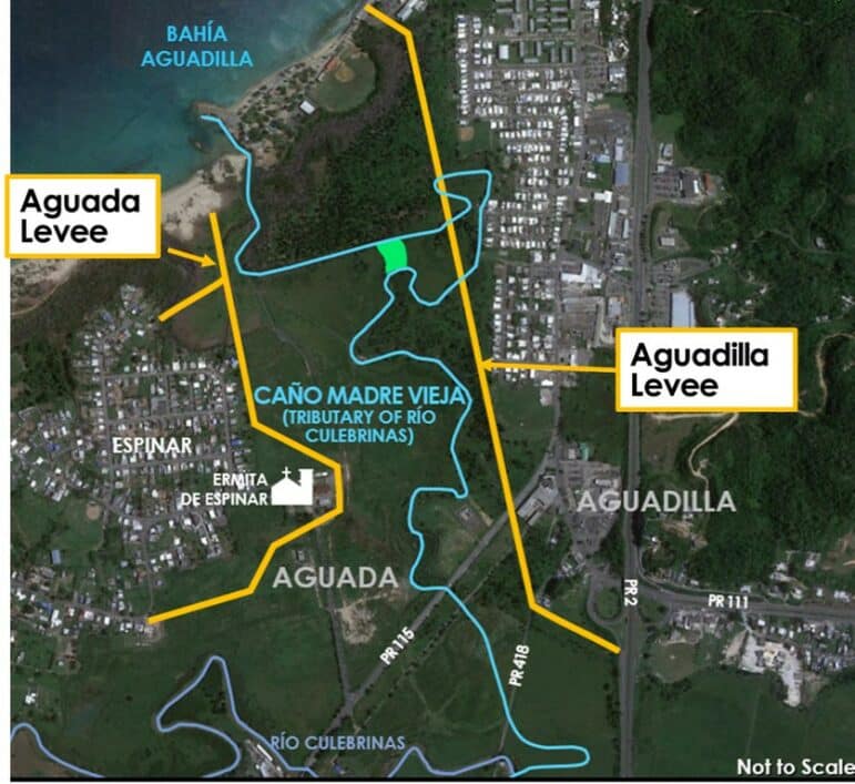
Photo provided by the USACE
“There would be absolutely nothing to protect us from flooding where the Culebrinas River is,” Vega said. “It’s such an invasive and large project, and although the purpose is to protect us from flooding, it’s going to flood us more. Since the levees aren’t built where they should be, the flooding is going to affect the Tablonal neighborhood more,” added the teacher.
Planner Santiago Bartolomei explained that the problem with levee channeling is that its design is based on hydrological data that is often not enough to adequately project the magnitude of flooding.
The Department of Transportation and Public Works (DTOP, in Spanish), which is sponsoring the flood control project in Aguada, assured that citizens will be consulted when the project is in a different stage.
“Right now, the project is in an early stage of technical studies for its design. We hope that more information will emerge as the project progresses. As a non-federal sponsor, we are very attentive to each stage and to the feelings of the citizens, who will be consulted at each stage of the project’s development,” the DTOP confirmed in written statements sent to the CPI.
Aguada residents interviewed by the CPI agreed that altering the flow of water in the Caño Madre Vieja area could cause communities in the Tablonal sector and the Espinar neighborhood to experience greater flooding events.
The Madre Vieja channel is on the border of the towns of Aguada and Aguadilla. It is an estuarine area of high ecological value that includes wetlands and mangroves. Aguada Mayor Christian Cortés Feliciano did not respond to the multiple requests for interviews the CPI made.
The residents of this western municipality are concerned that the project is based on 2004 studies that, in their opinion, do not consider the geomorphological changes of the Puerto Rican coast in the last two decades.
Javier López Vázquez, secretary of the Comité Ciudadanos Aguadeños Pro Conservación del Ambiente, believes that the construction of the levees in the Madre Vieja channel will affect 11 acres of wetlands and the habitat of species such as the brown pelican, which became endangered.
Photo by Jorge Ramírez Portela | Centro de Periodismo Investigativo
The conservationist leader criticized the fact that the USACE proposed this solution more than three decades ago and has not reconsidered whether it is the best current alternative to prevent flooding in the area.
The Culebrinas River flood control project is in the design phase. Its construction will take place between 2027 and 2033, the USACE stated. The estimated cost is $26.45 million.
According to the agency, the project will not harm ecosystems or marine species because “its engineering features are inland and will not affect marine ecosystems or species such as sea turtles or their nesting.”
In response to the complaints by Aguada residents, the USACE convened a meeting on May 11, for those who have expressed concern about the placement of levees in the Madre Vieja channel. The representative of the Tablonal community, Ramonita Méndez, was left with the impression that the USACE personnel were not familiar with the area’s geography or with the claims of the communities.
“With the swells and the rising river, [channeling] doesn’t protect Espinar or Tablonal because they’re going to hit this wall [of the levees in the Madre Vieja channel]. They don’t touch the Culebrinas River at all in the channeling [project],” Méndez said.
Foto por Jorge Ramírez Portela | Centro de Periodismo Investigativo
USACE recommended that DTOP or the Municipality of Aguada seek funding to relocate residents of the Tablonal community living within the existing flood zone. Although the effect on the Tablonal sector had been identified since 2004, the project did not include protection measures for this community because it “would require the relocation of hundreds of structures in the area” and is not cost-effective, according to USACE.
Unlike most flood control projects that are 100% federally funded, in this case, the costs of the Culebrina River project are shared between USACE (65%) and DTOP (35%) through supplemental federal funds authorized last year. Hydrologist and environmental engineer Ferdinand Quiñones believes the solution that the USACE proposes for the Culebrinas River has failed in other parts of the United States.
“Accelerating flood drainage without considering the long-term environmental effects, including the maintenance of levees, is not the best solution to coastal flooding,” Quiñones said on his Geography of Puerto Rico page on Facebook.
The engineer proposes that, instead of resorting to channeling or building levees, detention lagoons be implemented, as done in places in Europe and the United States.
“These lagoons are designed in such a way that they ‘capture’ the ‘peak’ of the flow of the floods and store it temporarily, discharging it little by little,” the scientist said.
The mayor of Aguadilla, Julio Roldán Concepción, whose municipality is also affected by the floods and the channelization project, said he asked the USACE to “update all this [data] before re-submitting it to the community.”
Roldán Concepción criticized the fact that the USACE could not present its damage mitigation proposal. “We’re talking about a channel that has flora, fauna, where different species live, and they presented nothing,” he said.
He also expressed concern that the maintenance of the Madre Vieja channel would be the DTOP’s responsibility. “They say that DTOP will provide the maintenance [of the channel]. What has DTOP done? The roads are abandoned,” the municipal executive added.
Agencies defend the projects
The USACE assured the CPI that it works with the government of Puerto Rico and other involved parties to find the most natural and environmentally sustainable designs. It said that all design solutions are coordinated with the DRNA.
According to the USACE and the government of Puerto Rico, channeling is the best solution to flooding in communities. The federal agency assured the CPI that the Río Piedras project has undergone changes since it was designed 30 years ago. According to the federal agency, once the project is completed, there will be more “green surface,” wastewater spillage into the river will be reduced, and a linear park will be built that will interconnect with the Luis Muñoz Marín Park in San Juan.
Puerto Rico’s Resident Commissioner in Washington Jenniffer González believes that updating the design is enough, even if an idea proposed 40 years ago is not revised.
“All these river channeling projects are done because of the effects caused every time a flood happens, when the lives of the people in those communities are put at risk, and certainly the property,” González said, in response to questions from the CPI. “These projects may have had their first investigation 40 years ago, but the Corps of Engineers doesn’t build with a 40-year-old blueprint. It involves multiple revisions for which I must regularly allocate funds in Congress to update them. In fact, this federal requirement means that nothing can be done if there is no input from the community,” she added.
The head of the USACE Jacksonville District Water Resources Branch and Projects Division, Milán Mora, agreed with the Resident Commissioner when approached by the CPI about the reviews that the proposed project has had.
“In the case of the Puerto Nuevo River [Río Piedras], yes, the studies are from 1986, but the models that are being done now are new. All the studies carried out by the Corps of Engineers are based on 50 years. The local community and the University of Puerto Rico are involved for comments,” Mora said.
The Resident Commissioner rejected the fact that there was no citizen participation as part of the planning process. She gave, as an example, the changes that she believes the project has had in response to resident requests.
“The community had asked us in 2017 to channel the part of University Gardens and Reparto Metropolitano (neighborhoods) that were in the original plan. However, two years later, the same community changed [their minds] and said they didn’t want it. What did we do? If they don’t want it, it won’t be done, but the floods will continue,” warned González. “The plans were altered to satisfy the request of that single community. So yes, the community is heard. The federal requirement is to listen to the community. Often, project costs double because you have to re-quote. On the ground, you find things that maybe weren’t there five years ago,” she added.
However, in a document produced by the USACE on March 23, 2023, the federal agency acknowledges that consultations with neighbors about the channeling of the Río Piedras were conducted in 1984 as part of the requirements of the “Environmental Impact Assessment for compliance with NEPA (National Environmental Policy Act)” and then in 2002 “with a finding of no significant impact (FONSI, in English).”
The USACE maintains that as “a supplemental NEPA is now being processed for project contracts in which a significant change to the original design has been identified,” there will be a public comment period. They also claimed that together with the DRNA “they have coordinated community meetings in different phases of the project with the main goal of informing the general public, answering their questions, and addressing their concerns.”
In May, the Resident Commissioner announced the creation of a Task Force for the US Virgin Islands and Puerto Rico to expedite pending USACE projects.
Riverbank protection
In addition to the technical aspects that concern the neighbors of the Río Piedras, the group also demands that the project allow them to coexist with the river and its banks.
At 3 p.m. on Saturday, June 24, when the temperature reached 99°F in the Jardines Metropolitanos neighborhood in San Juan, a small “ecological corridor” along a part of the Rio Piedras riverbank on Galileo Street in the neighborhood provides residents with shade and cooler temperatures.
The Puerto Rico National Weather Service bulletin for that day indicated that the heat indices would fluctuate between 100°F and 110°F in urban areas and near the coasts. That same afternoon, community leaders and environmental scientists met in the corridor to advocate for the importance of conserving green areas as protection tools in the face of the climate crisis and to raise awareness about the proposed USACE project that would affect the riverbank.
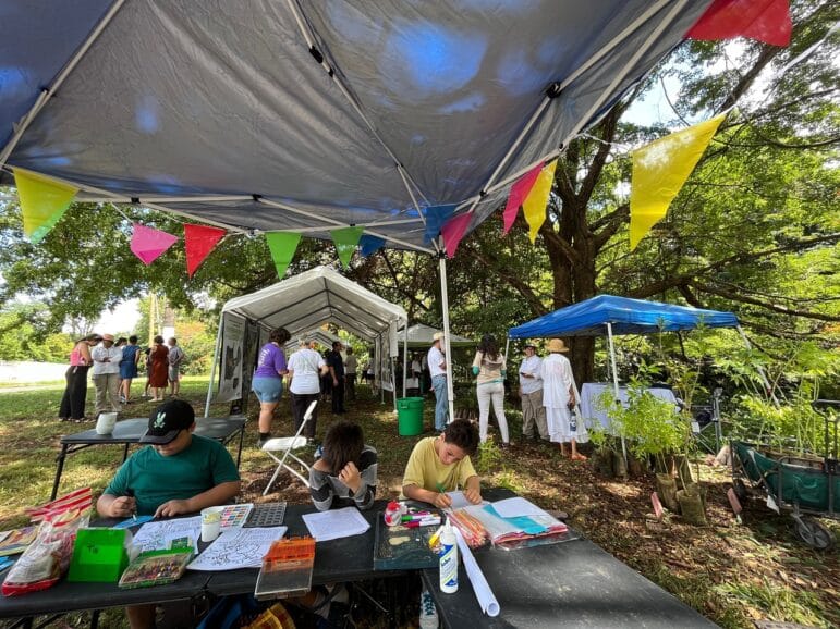
Photo courtesy of Ana Luisa Baca
The impact that the channelization may have on the river, fauna, and flora is one of the main concerns that residents expressed as part of a community investigation carried out between November 2022 and April 2023 by the Transdisciplinary Institute for Research and Social Action (ITIAS, in Spanish) of the University of Puerto Rico in Humacao (UPRH) and Guarda Río.
About 74% of the residents interviewed said they felt dissatisfied with the citizen participation process that the government of Puerto Rico and the USACE established, stating that there was not enough consultation or transparency in the information related to the project. Meanwhile, 75% of people expressed concerns about the channelization project. The consultation consisted of interviews with 257 households in the communities of University Gardens, Villa Nevares, and Jardines Metropolitanos. One person per household answered the questionnaire.
The study also revealed that 66% of the people interviewed know that a channelization project will be carried out in the middle basin of the Río Piedras. Some 58% of those who know it disagree with the project as it is presented. Another 22% said they were undecided.
According to the environmental sociologist and chief investigator of the study led by the UPRH and Guarda Río, Alejandro Torres Abreu, most of the people consulted believe the USACE never provided them with the necessary information about the project.
“There is no consultation process since the federal funds were approved and it is based on the premise that the communities agree. The main argument of both the local and federal governments is that it [channeling] is going to greatly reduce the flooding problem. Without having the data, without having run a formal citizen consultation process,” said Torres Abreu, who lamented that in Río Piedras the USACE did not practice the same principle of participatory planning that it adopted in response to the historical claims of the eight communities that surround Caño Martín Peña, where a different model was adopted from the one proposed originally.
In response to requests for greater participation from the communities that are part of the Río Piedras, on June 28, the USACE held a meeting with San Juan residents, environmental organizations, and staff from the Municipality of San Juan. DRNA representatives also participated, although virtually.
Other flood control models
In the state of Florida, the Kissimmee River underwent a channelization process that began in the 1960s in response to floods and hurricanes that affected communities on the peninsula. Although the project initially contributed to flood control, it also contributed to the destruction of the wetlands associated with the body of water, which caused a decline in species of birds, fish and mammals that were part of the biodiversity, according to research carried out in the area and agencies of the state of Florida, according to National Geographic.
Because of the adverse impact on the basin’s ecosystems, starting in the 1990s, the USACE itself, in conjunction with other state and federal agencies, began restoring the river to reestablish the habitats and ecological value that had been lost as a result of channeling.
“While many restoration projects attempt to reconstruct critical habitat features for individual species, the Kissimmee River Restoration Project is one of the few in the world to attempt reestablishment of the integrity of an entire ecosystem. Reestablishment of ecological integrity means that the river and floodplain ecosystem’s restored physical and chemical components will help drive recovery of the plant and animal communities associated with the river and floodplain before the Central and Southern Florida Flood Control Project,” according to the executive summary prepared by the South Florida Water Management District.
A report published by the National Geographic Society website reviews how the communities adjacent to the Kissimmee River presented opposition to the channeling project from the start because they believed that their relationship with the body of water would be altered. After the restoration of the river, many species have returned and have established themselves in those areas that they inhabited prior to channeling.
In the United States, restoration processes have also taken place in the Elwha River in the state of Washington and in the Los Angeles River in California.
When approached by the CPI on the case of the Kissimmee River as a possible model for the Río Piedras, USACE argued that the geomorphology of the watershed in San Juan is different from the case of the area in central Florida, so the cases are not comparable.
“Due to construction within a floodplain and high urbanization that encroaches up to the river banks, you have a situation [in San Juan] where businesses and residents are within a floodplain that experiences floods frequently,” the USACE explained.
According to the specialist in green-blue infrastructure and founder of the firm Urban Hydrologics, Pedro Santa Rivera, “a city that has more vegetation, more green and blue infrastructure, registers more productivity, more innovation, better grades at work. It has a multiplier effect in our society, and it is something that we must discuss.”
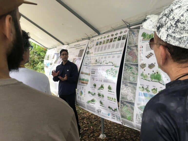
Photo courtesy of Stephanie I. Anderson-Morales
To achieve those goals and propose alternative models for the bodies of water in Puerto Rico, it is essential that the communities are at the center of decision-making, said Santa Rivera.
Manfred Fernández agreed with integrating the communities. She believes the USACE can accept the model implemented with the communities of Caño Martín Peña, where families were relocated to facilitate dredging, but as part of a consultation process and citizen participation.
“This must be seriously reconsidered because if not, the [Río Piedras] project is going to be unfortunate, more harmful than good. If it’s done in another way, taking a pause and rethinking where the river’s vital system is being affected, how to do it in another way, then perhaps the best possible project can be achieved that can be used as a model in other areas of Puerto Rico and who knows where else,” Manfred Fernández said.
In 2021, hundreds of people, including oceanographers, biologists, engineers, environmental lawyers, professors, scientists, doctors, and leaders of community and environmental organizations in Puerto Rico signed the 10-point Climate Crisis Declaration. The proclamation, which already has almost 800 signatures, demands from the Executive and Legislative Branches, among several public policy actions, the urgent prohibition of “the disappearance of wetlands and other estuarine systems, the channeling of rivers and other constructions that make us more vulnerable to floods and erosion.”